BMW 3: Set up map
Set up
1.  Press the button on the
Controller.
Press the button on the
Controller.
2. Move the Controller to the right.
3.  "Map settings".
4. Select the desired setting:
- "Map view": select the map view.
- "Direction of travel"
- "Facing north"
- "Perspective"
- "Zoom": select scale.
- "Auto zoom": with active destination guidance, the map is enlarged automatically when approaching a maneuver.
- "Manual zoom": enlarge or reduce map scale manually.
- "Route overview": display the route between current location and the destination.
- "Points of interest": symbols for Points of Interest are displayed.
- "Traffic flow": routes for traffic flow are displayed for Real Time Traffic Information RTTI.
- "Traffic events": symbols for traffic events are displayed for Real Time Traffic Information RTTI.
- "Guidance labels": when destination guidance is activated, destination guidance information along the route will be displayed.
- "Delay labels": if necessary, small information windows with the expected delay due to traffic jams are displayed on the map in the traffic bulletins.
- "Favorites": the icons for stored destinations are displayed.
- "Traffic lights": icons for traffic lights are displayed.
- "3D buildings": depending on availability and resolution, buildings may be shown in three dimensions in some scales.
- "Satellite images": depending on availability and resolution, in some scales satellite images are displayed as the background.
- "Additional settings": enter additional settings.
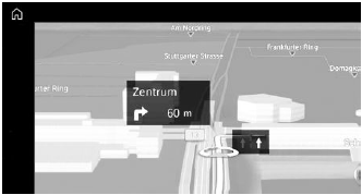
Destination guidance hints
Concept
If destination guidance is active, destination guidance hints can be displayed in the map view for the respective maneuvering points of the current route.
General information
In the case of multi-lane roads, lane information may indicate the recommended lanes.
The current vehicle position can also be displayed in the lane information.
Destination guidance hints can also be displayed as route preview on the split screen. When the route preview is active on the split screen, no lane information will be displayed.
Display destination guidance information
1.  Press the button on the
Controller.
Press the button on the
Controller.
2. Move the Controller to the right.
3.  "Map settings".
4. "Guidance labels".
Display
READ NEXT:
 Functions in the map view
General information
Different information can be called up for any
point on the map and settings can be adjusted.
Here, the map can alternatively be used via the
touchscreen.
Interactive map
Operatin
Areas to be avoided
Concept
Areas that should be driven around can be specified
as areas to be avoided.
General information
Stored areas to be avoided can be activated and
deactivated.
Defining an area to be avoided
1. S
Real Time Traffic
Information RTTI
General information
Depending on the equipment, RTTI is transmitted
via services which can be booked in addition
in some countries.
With RTTI, traffic obstructions are localized more
comprehensively
SEE MORE:
LED displays
Blue
The mobile phone is charging.
The blue LED stays illuminated once
the inserted mobile phone with Qi capability
is fully charged.
Orange
The mobile phone is not charging.
Temperature on the mobile phone
possibly too high or foreign object in
charging tray.
Red
The mobile phone is n
Belt drive
Comparison belt drive B46 engine and B46TU/B48TU engines
B46 Engine (transverse installation shown)
B46TU/B48TU engines (transverse installation shown)
Deflecting element
Alternator
Coolant pump
Air conditioning compressor
Ribbed belt
Torsional vibration damper
Belt tensioner
The
